Maps & Directions
 Twin Creeks Trailhead Lodge and Retreat
is located at the Homestead Trail Trailhead off Diamond Ridge Road, ten
minutes drive from town. Drive north on the Homer Bypass towards Anchor
Point. Turn right just past the edge of town on West Hill Road. Take a
left at the Diamond Ridge/Skyline Drive Y and wind your way up
the hill for 1.8 miles. TURN LEFT at Nearly Level Rd. (Lat/Long = 59 40
42.2 N, 151 36 00.8 W) . Follow the
bumpy driveway to the bottom of the hill. Turn left at the YURT and
follow to end of driveway. You will be right in front of the lodge sign
and building.
Click to see Google Map Twin Creeks Trailhead Lodge and Retreat
is located at the Homestead Trail Trailhead off Diamond Ridge Road, ten
minutes drive from town. Drive north on the Homer Bypass towards Anchor
Point. Turn right just past the edge of town on West Hill Road. Take a
left at the Diamond Ridge/Skyline Drive Y and wind your way up
the hill for 1.8 miles. TURN LEFT at Nearly Level Rd. (Lat/Long = 59 40
42.2 N, 151 36 00.8 W) . Follow the
bumpy driveway to the bottom of the hill. Turn left at the YURT and
follow to end of driveway. You will be right in front of the lodge sign
and building.
Click to see Google Map
Directions from Anchorage: After you
pass through Anchor Point drive approximately 10 more miles and look for
milepost 167. Turn left onto Diamond Ridge Road. Continue on up Diamond
Ridge Road 2.9 miles to Nearly Level Rd. sign and TURN RIGHT toward the sea. Go
down the 1/4 mile long driveway until you see the big white YURT ( large
round tent) and keep LEFT of yurt until you can't go any further and you
will be right in front of the lodge.
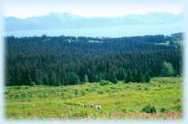
Homer Trails Alliance maintains the Homestead Trail during the summer months. The route winds
through the hills from the trailhead at the lodge to the southern
trailhead of the Baycrest Trail System.
 During
late spring and early summer, the upper meadows of the Homestead Trail
System serve as temporary feeding grounds for Sand Hill Cranes on their
annual journey north to their breeding grounds. Later in the summer, these
hills turn to bright pink as the fireweed blossoms mature. The trail winds
through these meadows of head high fireweed and other wild flowers to the
lower muskegs and moose habitat of the headwaters of Diamond Creek. During
late spring and early summer, the upper meadows of the Homestead Trail
System serve as temporary feeding grounds for Sand Hill Cranes on their
annual journey north to their breeding grounds. Later in the summer, these
hills turn to bright pink as the fireweed blossoms mature. The trail winds
through these meadows of head high fireweed and other wild flowers to the
lower muskegs and moose habitat of the headwaters of Diamond Creek.
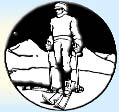
Click HERE for a large printable Ski Trail
Map (107k download) |

